船舶航经沿海养殖区附近注意事项

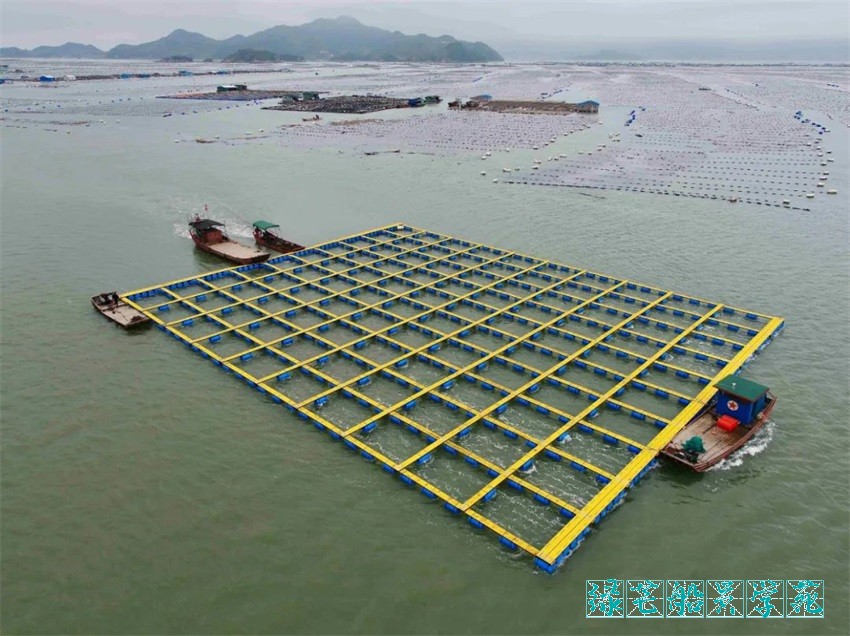
海上养殖区,是包括近岸网箱养殖、深水网箱养殖、吊笼(筏式)养殖和底播养殖等进行海上养殖的区域。近几年来,中国沿海误闯养殖区案件数量回升,给船东带来巨大损失与困扰。为此,公司特整理以下函件提醒所有船长及驾驶员,认真对待途径养殖区的航行,避免引起严重后果。
Fishery Farm is an area for Marine fishery culture, including near shore cage culture, deep water cage culture, hanging cage (raft) culture and bottom seeding culture. In recent years, the number of straying into Fishery farm cases has rebounded, causing great loss and distress to ship owners. To this end, we specially issue the following letter to remind all Captains and OOWs to take the precaution while navigating near the area to avoid serious consequences.
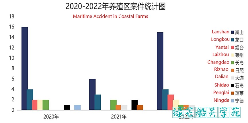
以下为最近三年(2020-2022年)不完全统计的船舶误入中国沿海养殖区案件的港口分布情况。
The following is the cases of ships straying into China's farm areas in the last three years (2020-2022).

上图中除大连和宁德外,其他港口均属于山东省,而岚山港养殖区因其位于日照港、岚山港及连云港三个港口的交界处,商、渔船通航环境复杂,商船避让他船及海上养殖区的可操纵水域受到较大限制,是案件数量最多的港口。
In addition to Dalian and Ningde in the above figure, other ports belong to Shandong Province. Because Lanshan fishery farm is located at the junction of Rizhao, Lanshan and Lianyungang port, merchant and fishing vessels navigation environment is complex. Maneuverable waters are greatly restricted for vessels to avoid other ships and Marine fishery farm, Lanshan farms induced to the largest number of cases.
船舶误入养殖区将造成非常严重的风险,养殖户不仅会向船舶提出高额索赔,还会要求船东出具高额现金担保,甚至会通过滞留船舶的方式逼迫船东现场结案。此类事件发生后,当地海事部门通常会对事故船舶进行详细的调查取证。船舶因为担保谈判及海事部门调查程序的影响,将面临船期严重损失的风险。另外也可能造成船舶本身损坏,比如尾轴密封损坏或螺旋桨损坏,甚至由于碰撞养殖设施而发生船体变形或者漏油导致污染事故。
The ship straying into the fishery farm will cause very serious risks, and the farmers will not only put forward high claims to the ship, but also require the ship owner to issue a high cash guarantee, and even force the ship owner to close the case on-site by detaining the ship. After such incidents, the local maritime authorities usually conduct a detailed investigation and evidence collection on the accident ship. Due to the impact of security negotiations and investigation procedures of maritime authorities, ships will face the risk of heavy loss of schedule. In addition, it may also cause damage to the ship itself, such as damage to the stern shaft seal or propeller, and even the hull deformation or oil leakage caused by collision with the facilities.
为了避免船舶进入养殖区,确保船舶沿岸及进港航行安全,请船长及驾驶员注意以下几点:
In order to avoid ships entering the farm area and ensure the safety of coastal navigation, please pay attention to the following points:
1. 进入养殖区海域前,必须通过代理获取当地有关养殖区分布的航行通告等信息,或者通过查阅海事部门的公告获取最新养殖区位置;
Before entering the area, it is necessary to obtain information such as navigational notices on the distribution of the local farm area through the agent, or obtain the latest location of the area by consulting the announcement of the MSA;
2. 制定计划航线时要考虑船舶避让需要和船舶位置误差,尽量远离养殖区,在海图上清晰标明养殖区范围。如存在海事局推荐的航路,建议船舶尽量沿此类推荐路线谨慎航行;
When planning the route, it is necessary to consider the ship avoidance need and the ship positioning error, stay away from the area as far as possible, and clearly indicate the scope of the farm area on the chart. If there is a route recommended by the MSA, it is advised to proceed as carefully as possible along such recommended routes;
3. 调整船舶航行计划,如果可行,尽量避开在夜间或者能见度不良时在养殖密集区航行;
Adjust the sailing plan and if feasible, try to avoid sailing in the intensive farming area at night or when the visibility is poor;
4. 船舶驾驶员加强心理戒备,严格遵守沿岸航行和交通密集区航行规定,缩短定位时间,确保船舶在计划航线航行;
OOWs should strengthen their psychological alert, strictly abide by the requirements for coastal navigation and navigation in dense traffic areas, shorten the positioning time, and ensure that the ship is sailing on the planned route;
5. 航行于养殖区附近时,船长必须在驾驶台密切跟踪。及早备车、备双锚、采用安全航速,加强对海面情况的瞭望,必要时增加驾驶台值班和瞭望人员,以及时发现和避开养殖区;
When sailing nearby, the Captain must monitor closely in the bridge. Standby the engine, prepare both anchors, adopt the safe speed, strengthen the lookout, increase the bridge duty/lookout personnel when necessary, and identify and avoid the farm area in time;
6. 明确辨识养殖区的实际分割标志,与海图标识对比,发现不同及时留下实际位置标识,作为下一次航行安全的依据;
Clearly identify the actual division mark of the farm area, compare it with chart marks, and mark the actual position in time for any difference, as for the safety of the next voyage;
7. 养殖区附近水域锚泊时,密切关注锚位,加强瞭望并关注大风天气和急流情况。一旦怀疑走锚立即采取措施,避免进入养殖区;
When anchoring in waters nearby, pay close attention to ship position, strengthen the lookout and pay attention to the wind and currents. Once the anchor dragging is suspected, take immediate measures to avoid entering the farm area;
8. 一旦发现误入养殖区,船长必须立即评估周围环境,切勿盲目操纵船舶造成损失扩大;
Once it is found that you have strayed into the farm area, the captain must immediately assess the surroundings, and do not blindly maneuver the ship to enlarge the loss;
9. 立即报告船东,请求并遵循船东指导采取进一步行动。
Report to ship owner immediately and follow the owner's guidance for further action.
沿海航行,由于交通密集度和海域空间问题,存在巨大的船舶碰撞、搁浅和入侵非正式航道等风险,需要船长和所有驾驶员充分准备及高度关注。海上养殖区由于存在区域随时变化、主管部门未及时监管和通知、损坏后责任判定混乱及可能的延伸事故等风险,需要船长及所有驾驶员高度关注。请大家重视养殖区航行安全问题,做到及早准备、认真执行、密切关注和建立故障应对预案,安全、顺利地通过海上养殖区,确保船舶顺利航行。随函附上目前中国沿海的各养殖区域分布图,其他地区如韩国、台湾等的养殖区也请船长和驾驶员及时关注,同样做好安全航行工作。这也需要我们日常养成做事严谨,考虑周全的做事风格,培养驾驶团队相互提醒、相互协助的团队精神。
Coastal navigation, due to traffic density and space limitations, there is a huge risk of collision, grounding and intrusion into informal waterways, which requires full preparation and high attention from Captain and all OOWs. Due to the risks of position changes frequently, failure of timely supervision and notification by the authorities, confusion in determining liability after damage and possible extended accidents, the Marine fishery farm needs attentions from the Captain and all OOWs. Please navigate safety nearby the area, make early preparation, careful implementation, pay close attention to and establish the response plan, safely and smoothly transit through the waters, and ensure the smooth navigation of the ship. Attached is the distribution map of various farms along the coast of China at present. For the farms in other areas, such as South Korea and Taiwan, please pay timely attention and also do a good job of safe navigation. This also requires us to develop a rigorous and thoughtful work style in daily life, and cultivate the team spirit of mutual reminder and mutual assistance of the navigation team.
附:中国沿海养殖区域分布图(该数据为2022年底,可能部分地区有更新,以海事部门的通知为准)
Distribution map of various farms along the coast of China at end of year 2022. Seek latest information from MSA.
一、山东省沿海海上养殖区分布情况 Shandong coastal

1. 莱州港附近养殖区 Laizhou

区域 S1:
1. 37°39.267′N 119°41.152′E
2. 37°39.266′N 119°40.350′E
3. 37°38.564′N 119°40.349′E
4. 37°38.565′N 119°41.158′E
区域 S2:
1. 37°44.251′N 119°46.158′E
2. 37°44.263′N 119°47.076′E
3. 37°44.964′N 119°47.086′E
4. 37°44.962′N 119°46.152′E
区域 S3:
1. 37°39.882′N 119°41.157′E
2. 37°39.880′N 119°39.543′E
3. 37°39.319′N 119°39.513′E
4. 37°39.300′N 119°41.131′E
区域 S4:
1. 37°44.026′N 119°45.152′E
2. 37°44.029′N 119°45.993′E
3. 37°44.863′N 119°46.004′E
4. 37°44.858′N 119°45.165′E
区域 S5:
1. 37°43.550′N 119°43.800′E
2. 37°42.730′N 119°44.000′E
3. 37°42.730′N 119°42.160′E
4. 37°43.545′N 119°42.000′E
区域 S6:
1. 37°44.623′N 119°42.939′E
2. 37°44.629′N 119°45.003′E
3. 37°44.800′N 119°45.001′E
4. 37°44.810′N 119°43.041′E
区域 S7:
1. 37°47.770′N 119° 49.700′E
2. 37°47.770′N 119° 48.800′E
3. 37°47.380′N 119° 48.800′E
4. 37°47.380′N 119° 49.700′E
区域 S8:
1. 37°47.380′N 119°49.700′E
2. 37°47.020′N 119°49.700′E
3. 37°47.020′N 119°48.800′E
4. 37°47.380′N 119°48.800′E
区域 S9:
1. 37°48.400′N 119°49.700′E
2. 37°48.400′N 119°48.700′E
3. 37°47.790′N 119°48.700′E
4. 37°47.790′N 119°49.700′E
区域 S10:
1. 37°47.000′N 119°48.500′E
2. 37°47.000′N 119°49.850′E
3. 37°46.500′N 119°49.850′E
4. 37°46.500′N 119°48.500′E
区域 S11:
1. 37°46.50′N 119°47.30′E
2. 37°46.50′N 119°49.85′E
3. 37°45.70′N 119°49.85′E
4. 37°45.70′N 119°47.30′E
区域 S12:
1. 37°45.69′N 119°47.30′E
2. 37°45.69′N 119°49.85′E
3. 37°45.10′N 119°49.85′E
4. 37°45.10′N 119°47.30′E
区域 S13:
1. 37°44.28′N 119°49.12′E
2. 37°45.08′N 119°49.12′E
3. 37°45.08′N 119°47.80′E
4. 37°44.28′N 119°47.80′E
区域 S14:
1. 37°34.850′N 119°43.00′E
2. 37°36.265′N 119°43.00′E
3. 37°36.265′N 119°43.50′E
4. 37°34.850′N 119°43.50′E
区域 S15:
1. 37°39.45′N 119°42.23′E
2. 37°38.84′N 119°42.23′E
3. 37°38.84′N 119°42.84′E
4. 37°39.45′N 119°42.84′E
区域 S16:
1. 37°39.30′N 119°41.20′E
2. 37°38.56′N 119°41.20′E
3. 37°38.56′N 119°41.80′E
4. 37°39.30′N 119°41.80′E
区域 S17:
1. 37°41.18′N 119°43 48′E
2. 37°40.85′N 119°43 48′E
3. 37°40.18′N 119°42.05′E
4. 37°40.85′N 119°42.05′E
区域 S18:
1. 37°39.88′N 119°41.26′E
2. 37°39.34′N 119°41.26′E
3. 37°39.34′N 119°42.06′E
4. 37°39.88′N 119°42.06′E
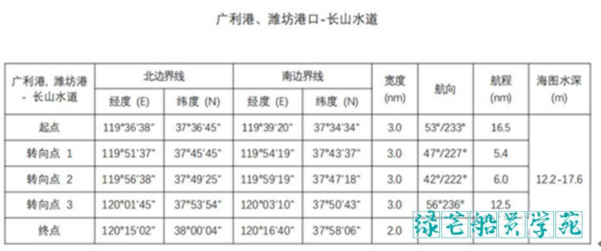
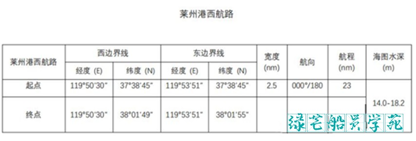
在莱州湾海域存在包括但不限于以上提及的多个海上养殖区,一些养殖区甚至扩张到推荐航路中。从长山水道驶出向潍坊港西行的船舶,或从蓬莱、龙口、其他北方港口驶往潍坊港的船舶进入莱州附近养殖区的风险很高。建议船舶应按照以下推荐航路航行避免进入养殖区。
There are many farms in Laizhou Bay, including but not limited to the above mentioned ones, some of which even extend into the recommended route. Ships sailing westbound to Weifang Port from Changshanshui Road or from Penglai, Longkou and other northern ports to Weifang Port have a high risk of entering the farms near Laizhou. It is recommended that vessels should avoid entering the area by following the recommended route.


2. 烟台港附近养殖区 Yantai
烟台至威海公共航路南侧海域海产养殖范围以下 4 点连线海域内存在海产养殖:
The following 4 points are farm areas connected to the sea area on the south side of the Yantai to Weihai public route:
37°38.99′N /121°46.83′E
37°39.35′N /121°55.17′E,
37°37.02′N/ 121°55.17′E
37°36.75′N/ 121°46.83′E.
养殖北边界与航路南边界距离 200 米,过往船舶应加强了望,谨慎驾驶,注意避让。建议船舶按照以下海事局推荐航路航行避免进入养殖区。
The distance between the northern boundary of farm and the southern boundary of the route is 200 meters, and passing ships should strengthen lookout and navigate carefully for collision avoidance. Vessels are advised to follow the following recommended routes to avoid entering the farm area.
图片
为防止船舶误入养殖区,海事局在上述烟台-威海航道上设立了 11 座 AIS 虚拟航标:
To prevent ships from straying into farms, the MSA has set up 11 AIS virtual beacons on the above-mentioned Yantai - Weihai waterway
1 号虚拟 AIS 航标(37-40.00N 122-06.60E),MMSI 994126108。
2 号虚拟 AIS 航标(37-41.60N 121-59.70E),MMSI 994126109。
3 号虚拟 AIS 航标(37-39.71N 121-59.85E),MMSI 994126110。
4 号虚拟 AIS 航标(37-41.33N 121-53.12E),MMSI 994126111。
5 号虚拟 AIS 航标(37-39.42N 121-53.31E),MMSI 994126112。
6 号虚拟 AIS 航标(37-41.06N 121-46.55E),MMSI 994126113。
7 号虚拟 AIS 航标(37-39.12N 121-46.74E),MMSI 994126114。
8 号虚拟 AIS 航标(37-40.78N 121-39.97E),MMSI 994126115。
9 号虚拟 AIS 航标(37-38.81N 121-40.17E),MMSI 994126116。
10 号虚拟 AIS 航标(37-40.50N 121-33.40E),MMSI 994126117。
11 号虚拟 AIS 航标(37-38.50N 121-33.60E),MMSI 994126118。
请参照航行。Please follow.
图片
海事局推荐航路(包括 11 座 AIS 虚拟航标)MSA recommended route
请注意:仍有一些无法识别的养殖区并未包含在上述通告中,在上述海域航行时值班船员应始终保持谨慎瞭望。
Please note: there are still some unidentified farms that are not included in the above notice, and the crew on duty should always exercise caution when sailing in the above waters.
3. 龙口港附近养殖区Longkou
图片
养殖区的范围由以下四个坐标点和海岸线所围成。
The range of the farm area is bounded by the following four coordinate points and the coastline.
A:37°41′30″N, 120°12′20″E;
B:37°50′00″N, 120°12′20″E;
C:37°50′00″N, 120°23′42″E;
D:37°43′50″N, 120°25′16″E。
特别提示:special remind
(1) 养殖区边界随季节变化,过往船舶应加强瞭望,谨慎驾驶,注意避让。
The boundary changes with the seasons, and passing ships should strengthen the lookout, navigate carefully, and pay attention to the route.
(2) 仍有一些无法识别的养殖区并未包含在上述航行通告中(如 K1、K2 两个无证养殖区)。
There are still some unrecognized farms not included in the above notice to mariners (K1, K2 two unlicensed areas).
K1
1. 37°40.1830′N 120°05.3641′E
2. 37°40.3809′N 120°05.4012′E
3. 37°40.3510′N 120°07.7620′E
4. 37°40.1509′N 120°07.7339′E
K2
1. 37°40.076′N 120°05.460′E
2. 37°40.057′N 120°07.860′E
3. 37°39.646′N 120°07.801′E
4. 37°39.629′N 120°05.365′E
4. 蓬莱港附近的养殖区 Penglai
图片
由下列坐标构成:It consists of the following coordinates
A:37°57′54″N, 120°48′48″E
B:37°58′00″N, 120°51′48″E
C:37°57′42″N, 120°52′42″E
D:37°55′24″N, 120°52′42″E
E:37°52′48″N, 120°49′30″E
F:37°52′56″N, 120°46′42″E
G:37°55′00″N, 120°46′22″E
H:37°55′53″N, 120°46′22″E
特别提示:Special notes
(1) 养殖区边界随季节变化,过往船舶应加强瞭望,谨慎驾驶,注意避让。
The boundary changes with the seasons, and passing ships should strengthen the lookout, navigate carefully, and pay attention to the route.
(2)仍有一些无法识别的养殖区未包含在上述范围,在该水域航行时值班驾驶员应当保持充分瞭望。
There are still some unrecognized farms not included in the above notice to mariners
5. 岚山港附近养殖区 Lanshan
图片
岚山港附近的海上养殖区地理范围如下:
It consists of the following coordinates
区域 A:
35°06′12.00″N, 119°50′16.00″E
35°03′18.00″N, 119°49′28.00″E
35°03′18.00″N, 119°46′48.00″E
35°06′12.00″N, 119°47′30.00″E
区域 B:
35°05′41.18″N, 119°54′03.73″E
35°04′21.77″N, 119°54′03.82″E
35°04′46.97″N, 119°54′45.81″E
35°05′35.97″N, 119°54′45.75″E
区域 C:
35°04′01.06″N, 119°52′29.91″E
35°03′26.77″N, 119°52′15.68″E
35°03′26.87″N, 119°53′56.63″E
35°04′01.14″N, 119°53′49.95″E
区域 D:
35°02′30.00″N, 119°36′11.0”E
35°02′18.00″N, 119°45′48.0″E
35°00′30.00″N, 119°45′48.0″E
35°01′18.00″N, 119°36′18.0″E
区域 E:
35°00′36.00″N, 119°35′18.0″E
34°59′42.00″N, 119°44′48.0″E
34°57′30.00″N, 119°40′42.0″E
区域 F:
35°11′23.43″N, 119°59′36.03″E
35°10′52.35″N, 119°59′36.03″E
35°10′52.34″N, 120°00′54.73″E
35°11′23.43″N, 120°00′54.74″E
区域 G:
35°10′52.40″N, 119°49′58.07″E
35°10′10.63″N, 119°49′42.15″E
35°10′10.75″N, 119°51′20.11″E
35°10′52.34″N, 119°51′32.20″E
区域 H:
35°10′01.66″N, 119°54′03.38″E
35°09′19.73″N, 119°53′52.84″E
35°09′19.65″N, 119°56′42.48″E
35°10′01.58″N, 119°56′32.59″E
区域 I:
35°00.21′N, 119°32.72′E
35°00.10′N, 119°35.48′E
34°58.10′N, 119°38.87′E
34°57.91′N, 119°37.79′E
34°57.89′N, 119°32.50′E
二、辽宁省沿海海上养殖区分布情况 Liaoning
大连港附近养殖区 Dalian
图片
大连新港的三个锚地 如图1,2,3标志,海上养殖区位置也如图标示。Anchorage area marked with No.1, 2 and 3
(1) 大窑湾锚地:通常情况下没有船舶在此锚地锚泊。No more in service
(2) 油轮锚地:到港油轮会按照大连 VTS 的指令在此锚地锚泊。For Tankers
(3) 货轮锚地:除油轮之外的其它船舶会在 VTS 的指令下在此锚地锚泊。For ships other than tankers
大连海上养殖区主要集中于1/2号锚地和3号锚地东北方向,由于其位置紧邻锚地,船舶误入养殖区的案件时有发生。近几年养殖区的面积在不断扩大,其具体区域也一直在变化之中,因此,上图养殖区边界位置仅供参考。考虑到国际航行船舶通常情况下从锚地南面航行进入锚地,在此情形下船舶在不向北穿越以下几点连线的情况下是安全的。
Fishery farm is mainly concentrated in the northeast direction of 1/2 and 3 anchorage. Because of its location close to the anchorage, the cases of ships straying into the area often occur. In recent years, the area of the zone has been expanding, and its specific area has been changing, so the location of the zone boundary in the above figure is for reference only. Taking into account that it is normal for ships to enter the anchorage by sailing from south of the anchorage, it is safe in this case for the ship not to cross the following lines to the north.
A 38°59.063′N, 122°02.923′E
B 38°57.775′N, 122°02.518′E
C 38°56.569′N, 122°03.503′E
D 38°55.731′N, 122°05.321′E
E 38°56.903′N, 122°07.820′E
三、福建省沿海海上养殖区 Fujian
1. 宁德附近养殖区 Ningde
地理范围:Position
A: 26-44.55′N, 119-38.05′E
B: 26-45.85′N, 119-47.32′E
C: 26-35.50′N, 119-50.07′E
图片
上图中的红色虚线代表有浮标标识的航道,在三沙湾的水道附近分布着密集的养殖区(图中黄色虚线标记),一些养殖区甚至分布在有浮标标识的航道中。
The red dashed line in the figure above represents the channel marked by buoys. There are dense breeding areas near the channel of Sanshawan (marked by yellow dashed line in the figure), and some breeding areas are even distributed in the channel marked by buoys.
图片
船舶误入养殖区主要发生在两个区域。Two areas with high risks of straying
区域 A:白匏岛附近的航道 route near Baibao Island
区域 B:青山岛东航道(如上图所示)。Route east of Qingshan Island
可能导致船舶误入养殖区案件发生的几点原因:reasons of straying into
(1) 上述两个水道中的洋流很强,流速可达 3-5 节。船舶顺流航行时,舵效不佳。Strange current with 3-5 knots
(2) 航道可航宽度很窄但转向角度却很大,使船舶操作起来极其困难。
Narrow channel with big alternation, causing maneuvering difficulties.
(3) 大量的渔船在航道内航行或穿越航道,使得船舶避碰或养殖场的避让水域有限。
Huge amount of fishing vessels nearby.
(4) 密集的海上养殖区分布在航道周围甚至航道中。若船只给他船让路后未能及时返回主航道,则很容易进入养殖区。
Intensive Marine farms are distributed around or even in the channel. If the ship fails to return to the main channel in time after giving way to others, it is easy to enter the farm area.
2. 南日岛附近养殖区 Nanri Island
图片
四、河北省的海上养殖区 Hebei
1. 京唐港和秦皇岛港附近养殖区 Jingtang and Qinhuangdao
养殖区的地理范围(图 A)
图片
北部地区:Northern part
39°46.206′N, 119°28.744′E
39°40.711′N, 119°36.201′E
39°38.203′N, 119°34.038′E
39°26.017′N, 119°31.535′E
39°25.809′N, 119°20.844′E
39°42.199′N, 119°23.656′E
中部地区:Middle part
39°23.764′N, 119°18.403′E
39°25.713′N, 119°18.897′E
39°21.526′N, 119°32.678′E
39°16.629′N, 119°29.753′E
39°12.272′N, 119°22.749′E
39°15.829′N, 119°18.321′E
39°14.676′N, 119°14.098′E
39°15.965′N, 119°12.594′E
39°18.878′N, 119°10.277′E
39°19.582′N, 119°10.184′E
南部地区:Southern part
39°17.134′N, 119°10.338′E
39°14.491′N, 119°13.459′E
39°13.931′N, 119°11.451′E
39°14.371′N, 119°10.998′E
上述区域外零星分布的养殖区(图 B):
图片
2. 黄骅港附近海域养殖区 Huanghua
图片
3 个海上养殖区的地理位置:
区域 1
A. 38°30′58.785″N, 117°50′09.520″E
B. 38°31′22.311″N, 117°51′13.607″E
C. 38°32′31.321″N, 117°50′19.209″E
D. 38°32′12.661″N, 117°49′23.219″E
区域 2
A. 38°30′15.713″N, 117°48′12.299″E
B. 38°30′36.743″N, 117°49′09.518″E
C. 38°31′53.501″N, 117°48′25.760″E
D. 38°31′34.229″N, 117°47′27.998″E
区域 3
A. 38°30′36.743″N, 117°49′09.518″E
B. 38°30′58.785″N, 117°49′09.520″E
C. 38°32′12.661″N, 117°48′23.219″E
D. 38°31′53.501″N, 117°48′25.760″E
图片
河北省的海上养殖区多位于京唐港和秦皇岛港之间以及黄骅港附近海域。来往于京唐、天津港、黄骅港和秦皇岛、锦州港之间的船舶建议将航线远离海岸设计,以免不慎进入养殖区。
Most of the Fishery farms in Hebei province are located between Jingtang Port and Qinhuangdao Port and near Huanghua Port. Ships traveling between Jingtang, Tianjin, Huanghua, Qinhuangdao and Jinzhou Port are advised to design their routes away from the coast to avoid accidentally entering.
- 发表于 2023-11-22 18:31
- 阅读 ( 838 )
你可能感兴趣的文章
相关问题
0 条评论
文件生成中...
请稍候,系统正在生成您请求的文件

船舶航经沿海养殖区附近注意事项

扫码过程中请勿刷新、关闭本页面,否则会导致支付失败
购买后请立即保管好,30天后需重新付费。

船舶航经沿海养殖区附近注意事项

扫码过程中请勿刷新、关闭本页面,否则会导致支付失败
购买后请立即保管好,30天后需重新付费。
请点击下载或复制按钮进行操作
